
Nestled in the Eastern Himalayas, Bhutan location captivates visitors on Bhutan tours with its pristine landscapes and vibrant Buddhist culture.
Overview of Bhutan Location
Brief Introduction to Bhutan
Bhutan, often called the "Land of the Thunder Dragon," is a small, landlocked kingdom nestled in the Eastern Himalayas. The Bhutan location is renowned for its breathtaking landscapes, vibrant cultural heritage, and unique Gross National Happiness philosophy, making it a hidden gem in South Asia.
This Bhutan country location features dramatic contrasts, from high-altitude valleys to subtropical plains, with over 70% of its land covered in lush forests. Bhutan's isolation has preserved its traditions, including colorful festivals and ancient monasteries. Understanding the location of Bhutan is key to appreciating how its geography shapes its identity as a Buddhist nation committed to environmental conservation.
Key Facts About Bhutan Country Location
The Bhutan country location spans roughly 38,394 square kilometers, comparable to Switzerland. With a population of about 770,000, it maintains a low density, allowing vast natural expanses. The Bhutan location features elevations from 100 meters in southern foothills to over 7,500 meters at Gangkhar Puensum, the world’s highest unclimbed peak.
Bhutan operates as a constitutional monarchy since 2008, relying on hydropower, tourism, and agriculture. Its commitment to carbon neutrality - absorbing more CO2 than it emits - stems from its unique location of Bhutan in the Himalayas, fostering biodiversity with over 5,400 plant species and rare animals like snow leopards. However, this Bhutan location faces climate change risks, such as glacial lake outburst floods, impacting its sustainable development goals.
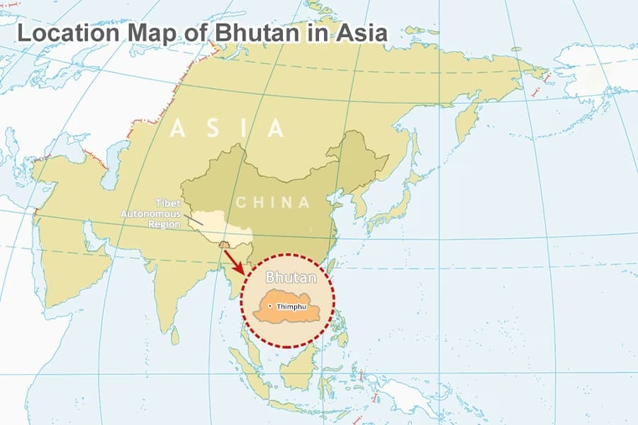
Location of Bhutan in Asia
Geographical Coordinates and Bhutan Location
The Bhutan location is precisely defined by its geographical coordinates: approximately 27.5142° N latitude and 90.4336° E longitude, placing it in the northern hemisphere and eastern Asia. Situated in the Eastern Himalayas, this location of Bhutan creates a subtropical-to-temperate climate, varying by altitude—southern regions are humid and tropical, while northern highlands are alpine.
Longitudinally, Bhutan aligns with Bangladesh to the west and Myanmar to the east, but its rugged terrain forms a natural barrier. The Bhutan country location uses Bhutan Time (UTC+6) without daylight saving. These coordinates highlight Bhutan’s role as a hydrological hub, with rivers like the Brahmaputra originating here, vital for regional ecosystems. For trekkers, the Bhutan location aids GPS navigation to remote trails, emphasizing its appeal for adventure tourism.
Neighboring Countries and Borders of Bhutan
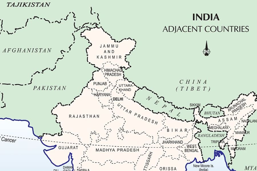
The location of Bhutan positions it between two major neighbors, shaping its geopolitical and cultural landscape. To the north, Bhutan shares a 477-kilometer border with China’s Tibet Autonomous Region, marked by Himalayan peaks. To the south, east, and west, it borders India across 699 kilometers, touching Sikkim, West Bengal, Assam, and Arunachal Pradesh. This Bhutan country location relies on India for trade routes, especially through Phuentsholing in the south.
As a landlocked nation, the Bhutan location lacks direct sea access, enhancing its seclusion. These borders protect unique ecosystems, with transboundary efforts like the Manas Tiger Reserve spanning Bhutan and India. The location of Bhutan fosters strong ties with India for security and economic support, balancing its isolation with regional connectivity.
Location of Bhutan in Asia Map
On an Asia map, the Bhutan map location appears as a small, rectangular nation nestled between China and India, part of South Asia alongside Nepal and Bangladesh. The Bhutan location in the Eastern Himalayas is highlighted by contour lines showing steep topography. Political maps emphasize its borders, while physical maps depict rivers like the Wang Chhu and mountain passes used in ancient trade.
The location of Bhutan is about 150 kilometers north of the Bay of Bengal, influencing monsoon patterns. Interactive Asia maps allow zooming into the Bhutan map location, revealing its isolation from urban centers like Delhi (1,200 km southwest) or Beijing (2,800 km north). This cartographic view underscores how the Bhutan location supports regional stability and environmental preservation.
Bhutan Map Location
Where Is Bhutan on the World Map?
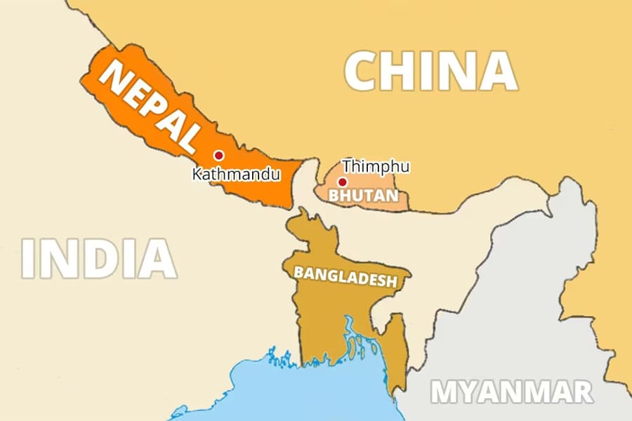
On a world map, the Bhutan map location is a small but significant spot in South Asia, within the Eastern Hemisphere. The location of Bhutan lies east of Nepal, separated by Sikkim, and north of Bangladesh, near the Tropic of Cancer, contributing to its climatic diversity. World maps highlight Bhutan’s sovereignty amid larger nations like India and China.
Bhutan country location at 27°N, 90°E underscores its historical role in silk route trade. Thematic maps often spotlight Bhutan for its happiness index, unique in global metrics. For travelers, the Bhutan map location points to Paro International Airport, nestled among peaks, a key entry point. This global perspective shows how the Bhutan location balances tradition with modern connectivity through UN membership and eco-tourism.
Bhutan Map Location in South Asia
In South Asia, the Bhutan map location positions it as a northern enclave, contributing to the region’s cultural diversity. South Asia maps place Bhutan with India, Nepal, and others, emphasizing its Himalayan terrain shared with Nepal. The location of Bhutan connects via Indian highways to ports like Kolkata, as shown in trade maps. Monsoon influences from the Indian Ocean shape its climate, visible in weather maps.
As a SAARC member, the Bhutan country location engages in regional cooperation for disaster management. Cultural maps highlight Bhutan’s Dzongkha language and Vajrayana Buddhism, distinct from Hindu-majority neighbors. The Bhutan map location also faces shared environmental challenges, like river basin flooding, reinforcing its role in regional harmony.
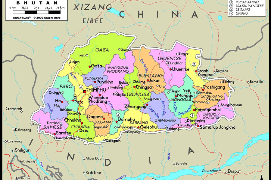
Key Cities and Regions on the Bhutan Map
The Bhutan map location reveals key cities and regions shaping its identity. Thimphu, the western capital, houses 115,000 residents and landmarks like Tashichho Dzong. Paro, also western, hosts the international airport and Tiger’s Nest Monastery. Punakha, in central Bhutan, features the historic Punakha Dzong at a river confluence.
Phuentsholing in the south is a trade hub with India. Eastern regions like Trashigang preserve traditional festivals. Bhutan’s 20 dzongkhags, grouped into western, central, and eastern zones, appear on administrative maps. Western areas are tourist-friendly, central Bumthang is a spiritual hub, and eastern regions remain remote. Physical maps show rivers carving valleys, linking these regions. The Bhutan location dictates lifestyles, from highland farming to lowland trade, rooted in its geography.