
The Bhutan map is a key to unlocking the wonders of this Himalayan kingdom, known for its stunning landscapes, rich cultural heritage, and commitment to Gross National Happiness. From the vibrant valleys of the west to the remote peaks of the north, the country of Bhutan map reveals a land of diverse regions, each with its own unique attractions. This article explores the geography, cultural highlights, and practical uses of the Bhutan country map, guiding travelers through the kingdom’s regions and helping them plan an unforgettable journey. Many Bhutan vacation packages make use of the Bhutan map to highlight the best destinations, ensuring visitors experience the most authentic and memorable aspects of the country.
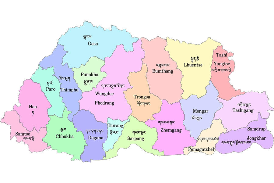
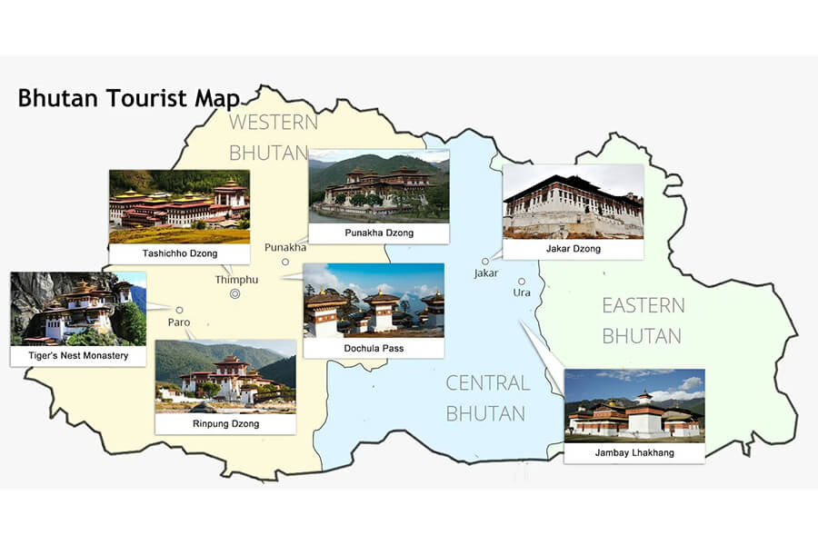
Western Bhutan on Bhutan Country Map
Western Bhutan, prominently featured on the Bhutan map, is the gateway for most travelers, home to the capital, major cultural sites, and scenic valleys.
Paro, Thimphu, and Haa Valley Highlights
On the kingdom of Bhutan map, western Bhutan includes Paro, Thimphu, and the lesser-known Haa Valley. Paro, home to Bhutan’s only international airport, is a must-visit, with the iconic Paro Taktsang (Tiger’s Nest Monastery) perched on a cliff. Thimphu, the capital, is marked by its blend of tradition and modernity, featuring landmarks like the Tashichho Dzong and the Buddha Dordenma statue. Haa Valley, a hidden gem, offers serene landscapes and cultural treasures like Lhakhang Karpo and Nagpo. These destinations make western Bhutan a focal point on the Bhutan country map.
Cultural and Historical Attractions in Western Bhutan
Western Bhutan is rich in cultural landmarks, as shown on the map of Bhutan country. Paro’s Rinpung Dzong and Thimphu’s National Museum preserve Bhutan’s history, while festivals like the Paro Tshechu bring the region to life with masked dances. Haa Valley’s annual summer festival showcases traditional sports and music, offering a glimpse into local life. These attractions, easily located on a Bhutan map, make western Bhutan a cultural hub for visitors.
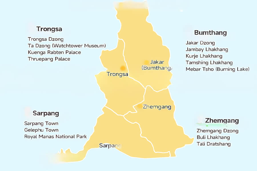
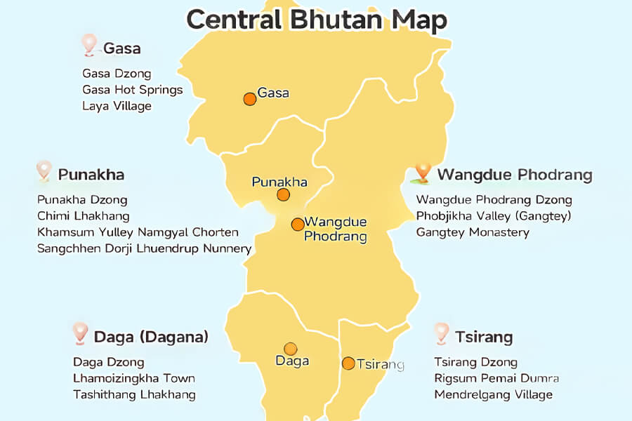
Central Bhutan on Map of Bhutan Country
Central Bhutan, a vital region on the Bhutan country map, is known as the spiritual and cultural heartland, with historic monasteries and scenic valleys.
Bumthang, Trongsa, and Gangtey Monastery
The map of Bhutan country highlights Bumthang, Trongsa, and the Phobjikha Valley, home to Gangtey Monastery. Bumthang, often called the “spiritual heartland,” is dotted with ancient temples like Jambay Lhakhang and Kurjey Lhakhang. Trongsa, centrally located, boasts the majestic Trongsa Dzong, a fortress with panoramic views. Gangtey Monastery, nestled in the Phobjikha Valley, is a serene retreat surrounded by meadows, making it a key landmark on the Bhutan map.
Heartland of Bhutan’s Spiritual and Cultural Heritage
Central Bhutan’s cultural significance is evident on the kingdom of Bhutan map. The region is home to sacred sites tied to Guru Rinpoche, the founder of Tibetan Buddhism in Bhutan. Bumthang’s festivals, such as the Jambay Lhakhang Drup, feature sacred dances, while Trongsa’s historical role as the seat of Bhutan’s monarchy adds depth to its heritage. The Phobjikha Valley’s black-necked crane festival celebrates conservation, making central Bhutan a spiritual cornerstone on the Bhutan country map.
Eastern Bhutan on Kingdom of Bhutan Map
Eastern Bhutan, less explored but equally captivating, is a region of rugged beauty and unique traditions, as depicted on the kingdom of Bhutan map.
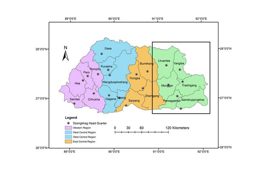
Mongar, Trashigang, and Remote Valleys
The Bhutan map showcases eastern Bhutan’s key towns, Mongar and Trashigang, alongside remote valleys like Merak-Sakteng. Mongar is a gateway to the east, with its dzong and vibrant markets. Trashigang, a cultural hub, features the historic Trashigang Dzong and serves as a base for exploring remote areas. Merak-Sakteng, home to the semi-nomadic Brokpa community, offers a glimpse into Bhutan’s isolated communities, accessible via trails marked on the country of Bhutan map.
Unique Languages and Traditions in Eastern Bhutan
Eastern Bhutan’s distinct identity is reflected in its languages, such as Sharchopkha, and unique traditions. The Bhutan country map highlights regions where festivals like the Gomphu Kora Tshechu celebrate local culture with music and dance. The Brokpa’s yak-based lifestyle and traditional attire add to the region’s diversity. These cultural elements, rooted in eastern Bhutan’s geography, make it a fascinating area to explore on the Bhutan map.
Southern Bhutan on Country of Bhutan Map
Southern Bhutan, as shown on the country of Bhutan map, is a vibrant region known for its border towns and cultural diversity.
Phuentsholing and Border Towns
Phuentsholing, the main gateway from India, is a prominent feature on the Bhutan map. This bustling border town is a commercial hub, with markets and the Zangto Pelri Lhakhang temple. Other southern towns, like Samtse and Gelephu, also serve as trade centers, connecting Bhutan to its southern neighbor. These towns, marked on the map of Bhutan country, offer a lively contrast to Bhutan’s quieter northern regions.
Trade, Commerce, and Cultural Diversity
Southern Bhutan’s proximity to India fosters a unique blend of Bhutanese and Nepali cultures, evident in the kingdom of Bhutan map. The Lhotshampa community, speaking Nepali (Lhotshamkha), adds to the region’s diversity, with festivals and cuisine reflecting this multicultural influence. Phuentsholing’s markets are vibrant with trade, offering textiles, spices, and handicrafts. The Bhutan country map highlights this region as a gateway to Bhutan’s economic and cultural exchange.
Northern Bhutan on Bhutan Country Map
The northern region, as depicted on the Bhutan map, is a land of towering peaks and pristine wilderness, ideal for adventure seekers.
Himalayan Peaks and Protected Areas
Northern Bhutan, marked on the country of Bhutan map, is dominated by the Himalayan range, including peaks like Jomolhari and Gangkhar Puensum, Bhutan’s highest mountain. Protected areas like Jigme Dorji National Park and Bumdeling Wildlife Sanctuary are home to rare species like snow leopards and black-necked cranes. These areas, clearly outlined on the Bhutan country map, are critical for conservation and adventure tourism.
Trekking Routes and Adventure Tourism
The Bhutan map is a guide to northern Bhutan’s renowned trekking routes, such as the Snowman Trek and Jomolhari Trek, which offer breathtaking views of the Himalayas. These trails, winding through high-altitude passes and remote villages, attract adventurers worldwide. The kingdom of Bhutan map also highlights areas for wildlife spotting and camping, making northern Bhutan a paradise for outdoor enthusiasts.
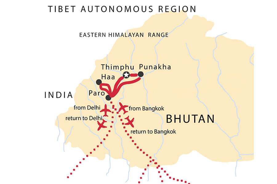
Using Bhutan Map for Travel Planning
A Bhutan map is an essential tool for planning a trip, helping travelers navigate the kingdom’s diverse regions and attractions.
Tourist Circuits and Bhutan Trips
The map of Bhutan country outlines popular tourist circuits, such as the Paro-Thimphu-Punakha route, which covers western and central Bhutan. More adventurous travelers can use the Bhutan country map to plan trips to eastern Bhutan or multi-day treks in the north. Tour operators often provide detailed maps to guide visitors through cultural sites, festivals, and nature trails, ensuring a comprehensive Bhutan experience.
Digital and Interactive Resources for Exploring Bhutan Map
Digital tools enhance the utility of the Bhutan map. Online platforms like DrukGIS and Bhutan Tourism’s website offer interactive maps with details on attractions, accommodations, and transport routes. Mobile apps provide real-time navigation, while printed Bhutan country maps are available at visitor centers in Thimphu and Paro. These resources make it easy to explore the kingdom of Bhutan map, ensuring a seamless travel experience.
Conclusion
The Bhutan map is more than a navigational tool; it’s a gateway to the kingdom’s cultural, spiritual, and natural treasures. From the vibrant west to the remote east, the serene south to the rugged north, the country of Bhutan map reveals a land of diversity and wonder. Whether you’re planning to visit Paro’s Tiger’s Nest, trek the northern Himalayas, or explore the cultural heartland of Bumthang, the Bhutan country map guides you through an unforgettable journey. Embrace the Bhutan map to discover the magic of the Land of the Thunder Dragon.